Weekend Snowstorm and Blizzard for some

650x366_02132024_hd23-2

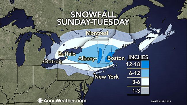
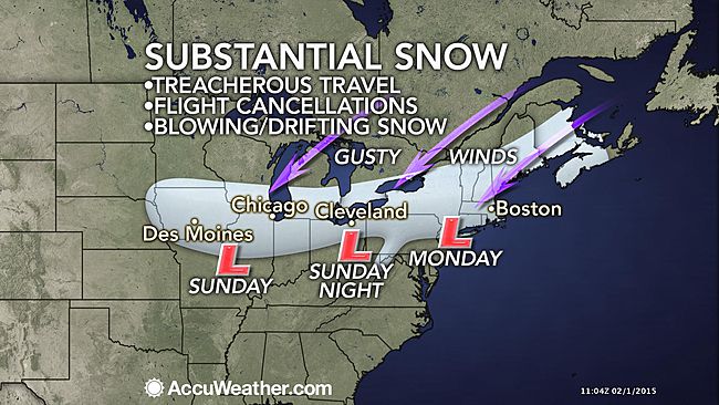
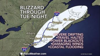
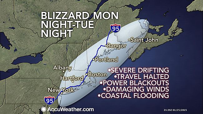
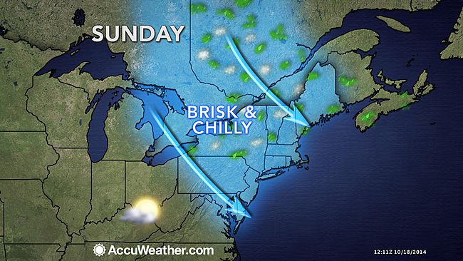
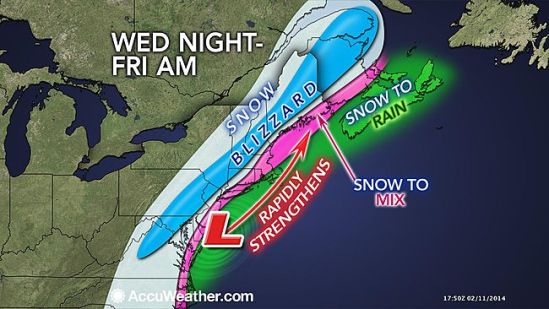
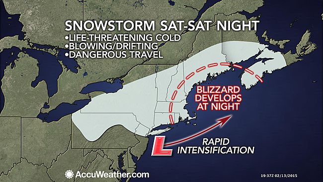
A storm passing through the Northeast this Valentine’s Day weekend is riding a tidal wave of frigid air and will evolve into a blizzard over New England before departing on Sunday. The worst of the storm will target the eastern New England coast Saturday night into Sunday with wind-driven snow. However, high winds, fierce cold and some snow will reach back through CT and southern New England. There will be an arctic front associated with the storm on Saturday night. The arctic front will behave like a squall line, but instead of bringing heavy rain, it could bring a brief period of heavy snow with perhaps thunder and lightning. As the storm moves off the New England coast it will strengthen rapidly and deliver blizzard conditions from eastern Massachusetts, Rhode Island and eastern Connecticut to southeastern New Hampshire, and coastal Maine. On Saturday, as snow squalls roll across the mid-Atlantic and western New England, the storm will start off on a tranquil note. While winds will remain light during the day Saturday, snow will spread over much of the region and pick up the pace in the afternoon in western areas. During Saturday night, increasing wind, plunging temperatures and heavier snow will lead to dangerous travel for the entire area. On Sunday, snow and blizzard conditions will continue in New England for a time as even colder air empties into the region. Strong wind gusts will continue to make for dangerously low wind chills, and the chance for power outages. When it’s all said and done, southern CT should expect a general wind-blown 4-8 inches of snow, but I won’t be surprised if there are some 10-12 inch totals especially in eastern areas. Stay warm and stay safe! -SS

Another round of snow and ice heading in

650x366_02072012_hd25.

As the last storm in this series of storms heads in, It will be the strongest of the bunch. This storm will feature a wide range of snow and ice totals. With the heaviest falling from northern CT on northward. There will be a swath near Boston and southern Vt that could see up to 2 feet! There will be a general 8-12 for most of the northeast, with the exception of southern coastal CT that gets only 3-6 because of some mixing and changing to sleet and freezing rain on Sunday night, before changing to all snow on Monday morning. The bulk of the snow should be gone by Monday night, but some lingering snow showers should stick around until Tuesday for the mountains of northern New England. There is another chance for some snow on Thursday, and that storm will be followed by the coldest air of the season. Stay tuned! -SS

Ground Hog Day Storm!

650x366_02011105_hd20-1

Here we go again! Where is Bill Murray when you need him? There is a very large storm sweeping out of the midwest and heading into our area overnight tonight. It should arrive sometime around the end of the big game. This will be a rough scenario for all the people trying to make it home after the game. The storm is strengthening as it gathers moisture from the Pacific Ocean, Gulf of Mexico, and eventually the Atlantic ocean. The snow will be heavy tonight with accumulating snow through the night on the order of 5-8 inches. Even though temps will be cold in the 20s, this storm will be deepening and moving just to our south, this will in turn change our precipitation to sleet and freezing rain in the morning. This will create a very dangerous situation for the morning commute, as there can be significant icing in some places. As the storm moves away, it will drag down very cold air in behind it, and change it back to all snow by the afternoon We could see another 2-4 inches of snow and ice tomorrow, bringing our storm total to 8-12 inches. This number could be a little higher inland where it could stay all snow, or only ice for a short period of time. Also, along the immediate coast it could ice for a longer period, therefore allowing for lesser snow totals. The temperatures will drop rapidly tomorrow night to around 0 degrees. This will create a flash freeze, in turn freezing any slush and standing water very rapidly. This storm is poised to drop a huge swath of snow across a large area. It will create very a hazardous and deteriorating condition throughout the entire region. Leave extra time in the morning if you must travel, and if it does go to freezing rain and sleet, travel will be nearly impossible. There will also be some snow showers in the area for Wednesday and Thursday, and it is far away but it looks like a ground hog day scenario as we are watching another storm for next Monday! It is far away, but it is something to watch. Stay classy and enjoy the Super Bowl! -SS

A Boom or Bust kind of Storm

650x366_01271205_hd22-3

Alright everybody, before you go calling for all the meteorologists heads lets talk about what actually happened. First of all I do agree that there was a ton of hype just like there always is, but it doesn’t take much for forecasts to change as storms happen. This storm as it formed, ended up getting its act together about 50-100 miles east of where it was predicted to do so. Thus, keeping the super heavy snow bands confined solely to eastern New England. In my forecast I called for a widespread 1-2 feet, which is spot on, but we will just be on the low-end of it. I also said there will be an area that gets 30 inches or even as much as 40 inches. This will also still happen somewhere in eastern New England. Probably somewhere in Eastern Mass will come in with the big winner. Shrewsbury, MA is coming through with the most so far, right around 30 inches. The winds also have been as forecast, with gusts  blowing 40-50 mph throughout the entire area. Also, like i stated the Cape an islands have been getting hammered with stronger gusts. On the Vineyard a gust of 78 mph was recorded, which is above hurricane force! Also, currently the entire island of Nantucket is without power.

So while here in most of western Connecticut, this feels like a big bust, It actually will be spot on with my forecast. I agree that meteorologists and news people alike tend to hype big storms, and in turn clean out grocery stores. There is some good reason to this, as people need to heed warnings and prepare for the worst case scenario. As it turns out, the worst case scenario has not come to fruition, and this is a good thing so people will not have as big a cleanup and life can return to normal sooner than first thought. Everybody enjoy your snow day, and stop hating on the weather service. Stay classy! -SS

Steviestorms is coming in hot!

weather

I tried to write this earlier tonight, but had a crash and lost the whole thing… so here goes again…

A monster blizzard is poised to cripple the entire area. A clipper system will move out of the midwest and into the mid-Atlantic on Monday. It will then slide off the coast, strengthen rapidly and head towards the northeast. Everyone in the area should prepare for a potentially ‘historic’ storm. Snow showers will arrive in the morning on Monday, transitioning to light snow in the afternoon, and eventually an all out full fledged blizzard into the overnight. This storm could be the biggest of the year, and maybe even biggest ever in some places. There is an obscenely large swath of 1-2 foot snowfall from NYC through Maine. There will even be a bullseye of snow somewhere in southern New England that wins the medal and gets 2-3 feet!! There could be a big winner out there with 40 inches or more!! Unlike last storm, the cold air is in place so the precipitation will be all snow. It will also be quite cold so the snow to liquid ratio will be anywhere from 15:1 to 20:1. The average is usually around 10:1. (inches of snow from one inch of rain) The other aspect of this storm will be the intense winds. With sustained winds of 25-30 mph, and gusts to 60 mph, this will yield drifts of 4-6 feet! Gusts out on the cape could even top hurricane force! These strong winds off of the water will also create some minor to moderate coastal flooding along the entire coastline. During the height of this storm on Monday night, travel of any sort is discouraged as it will be nearly impossible. It will be so bad that all traffic will be halted for a time. Many roadways will be impassable for hours if not days after the storm ends. Power outages are also possible due to the heavy snow and strong winds. Conditions will improve by Wednesday, allowing crews to begin the clean-up process in the wake of this monster storm. Dry conditions wont last long though, as another clipper system will move through Thursday night into Friday. It could drop a few more inches on us as it slides by. Lastly, the storm has the chance to deliver one of my favorite weather phenomenon of all time….. THUNDERSNOW!!!!! This storm is so intense, that some of the snow bands tomorrow night could produce thunder and lightning that will accompany the falling snow. This is going to be a good one! Saddle up people! -SS

Dr Stevie Storms is back!

As the temps start to drop, it is time for Stevie Storms to make his comeback! The temps will be dropping sharply overnight tonight into Sunday. Many locations across the Northeast will feel like mid-November as the weekend progresses with the arrival of colder air and gusty winds. After a warm and rainy week, a blast of chilly air from Canada will arrive in the Northeast for the weekend. Many locations experienced temperatures between 15 and 20 F above average for this time of year this past week. However, by Sunday many locations will run 5 to 10 degrees below average. The 20- to 30-degree change will be quite noticeable for many people. A cold front will breeze through the area this weekend with spotty showers. Temperatures might even be low enough to see the first snowflakes of the year in some areas of northern New England into Sunday morning. The chilly air will settle in on Sunday on gusty northwest winds across the entire Northeast. The November-like conditions will persist over the Northeast into the beginning of next week. A storm system off the mid-Atlantic coast during the middle of next week could bring periods of heavy rain and gusty winds to the entire region. Expect another post to follow on the potential for a midweek Nor’easter coming up this week! -SS

650x366_10181433_hd12

Another Tuesday storm

Another Tuesday storm

Another Tuesday, another storm! Here we go again, it feels like Groundhog Day. A storm will move out of the Midwest and into the northeast during the day on Tuesday. Snow will start by about 6 or 7 am for the western part of the state and it will work it’s way east. Snow will get heavy by late morning, and it will continue into the afternoon. Temperatures will slowly rise above freezing by the afternoon, and the snow may mix with or change to rain right along the coast. Most areas should expect 2-4 inches of snow, with the highest amounts inland where they can expect 4-5 inches. It should all be done by the mid-late afternoon. This storm also brings with it some good news, as it will usher in some warmer weather for the rest of the week! Highs will approach 50 for most places on Friday! Don’t get too excited though as temperatures will drop back down to seasonal levels by the start of next week. -SS

Second feature moving through tonight!

20140213-183008.jpg

Welp I hope everyone enjoyed the sweet first half of this storm! A general 9-12 inches has already fallen throughout the area, with another 2-4 expected tonight. The worst is over, but it could still be pretty bad tonight when the heavy bands of snow move back through along with some gusty winds! This monster storm is rolling by to the east tonight, and as it moves away it will wrap back around a good size batch of moisture through the area.
Here in southern CT, a light wintry mix will continue through the evening hours. By 8-10 pm the precip should change back over to all snow and pick up in intensity. Everything should be done by sunrise Friday morning. It looks like there will be a whole lot of delays for schools tomorrow, and even some closings.
I hate to mention it now, but it looks like another storm will move through the area during the day on Saturday, dropping a light 1-3 inch snowfall! I’ll keep you all posted! -SS

Monster Nor’easter for late tonight into Thursday

Monster Nor'easter for late tonight into Thursday

A storm bringing heavy ice and snow to the interior Southeast will reach the Northeast Wednesday night and Thursday with heavy snow and gusty winds. This is a very strong and complex storm! As I write this the storm is dropping a historic ice storm on much of the southeast US! Conditions could be catastrophic down there with hundreds of thousands of people without power. As the storm moves up the eastern seaboard today and tonight it will interact and ‘phase’ with an upper level low pressure system that’s moving out of the mid-west. As these storms phase together and combine their powers to form a super-storm nor’easter, it will create my all time favorite weather term… Bombogenesis!! This means the storm will ‘bomb out’ or rapidly strengthen and intensify as it heads up the northeast coast. This will make for potentially the biggest storm of the year for some parts of the mid Atlantic and northeast. As it moves up the coast the exact track is the key here as a subtle shift of 40-50 miles in storm track could mean the difference between just a couple of inches of snow to well over a foot.
The way it looks now, New Haven can expect 6-10 inches before mixing with and changing to freezing rain and sleet and depending on the exact track, even plain rain in the afternoon tommorow. Even if it does change over, all areas will go back to all snow before ending
Thursday night! Inland CT and MA can expect over a foot with the potential for 14-18 inches where it will stay all snow.
The snow should start in the New Haven area around 2 or 3 am overnight Wednesday into Thursday morning. It will become very heavy in the morning and travel will be very treacherous if not impossible.
The big winner here as it looks now (all could change depending on storm track) will be northwestern CT, western MA, southern VT and NH, and heading northeast into Maine. All schools in CT and across NE should be closed tomorrow. Enjoy your snow day kids and teachers. I will update again tonight as the storm approaches and confidence increases on the exact storm track! -SS

It’s go time !

20140204-212921.jpg

Sorry I have been quiet all but I am in Vermont preparing to shred this beast! Winter is finally rearing her beautiful face and she is ready to rip. Right on the heels of the early week storm, comes another behemoth. We also have a potentially bigger storm for the end of the weekend!

Dealing with this current monster is fun, because this looks like a real good chance for widespread 1ft + snowfall for most of the northeast. Not so much in CT, but still a significant storm none the less. Parts of CT should see a foot or more, but that will be confined to the northern half of the state. Especially in the northwest hills where there could be over a foot! Along the coast there should be 3-6 inches of snow with a nice sleet layer and then up to a quarter inch of freezing rain on top.

All precip should start pre-dawn and should be very heavy through the morning hours. With Snowfall rates of an inch an hour or more in some places! The snow will stay falling heavy at times in the inland, but along the coast it will mix with and change to freezing rain and sleet. In some warmer spots right on the coast, it will be just warm enough for it to go to all rain. All precip should be done by the evening hours from west to east.

This is not going to be a very long duration event, but the precip will be very heavy much of the time. Exercise extreme caution if you have to be out tomorrow. Take it slow on the roads.

More to come on this weekend storm and don’t look now but there is even a valentines day storm in the works! More to come! -SS